
Storm Tracker: tornado warnings in River Country

Friday weather watch:
11 a.m. Tinker Air Force Base in Oklahoma City expects sunny skies this afternoon with a high temperature in the low 80s. Clouds diminishing at Tulsa at noon with a slight chance of rain.
Storms at Springfield, Mo., through 1 p.m.
12:26 p.m. Tornado warning for Buffalo County near Rockville. Public reports hail from dime to half-dollar size.
1 p.m. – Emergency management reports tornado in Sherman County near Howard City, Neb.
1:49 p.m. – Fire department reports funnel cloud at Friend, Neb., in Saline County. 1.25” hail west of Dorchester. Hail near Fairbury.
2:29 -p.m. – Storm Prediction Center in Norman, Okla., updates Saturday risk map to include southeast Nebraska, northwest Missouri and northern Kansas in enhanced risk.
2:26 p.m. – cell A4 forming west of Burchard, tracking toward Crab Orchard and Syracuse.
2:30 p.m. – Tornado warning for Lancaster, Saunders counties. Boone County, Seward County, Nancy County.
3:15 p.m. – Tornado warning for Cass County. Radar indicates rotation in northern Lincoln.
4:47 p.m. – Tornado warning issued after severe thunderstorm reported near Verdon. Radar indicates rotation.
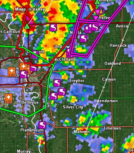
4:48 p.m. – Severe thunderstorm warning for Mills County, Iowa, and Nemaha County, Neb.
4:51 p.m. – OPPD reports 6,000 power outages in Douglas County, 3,430 in Saunders county.
4:56 p.m. – tornado warning to 5:45 p.m. in central Fremont County.
4:57 p.m. NWS reports funnel cloud east of DuBois in Richardson County.
5:15 p.m. - Richardson County Emergency Management confirms tornado near Shubert. Baseball sized hail is a hazard.
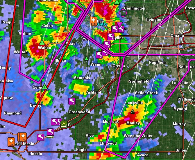
5:26 p.m.- Truck with cattle trailer on fire on I80 near Greenwood. Law enforcement reporting houses level west of Highway 75 and Highway 133 in Washington County.
5:35 p.m. – OPPD reports 100 power outages in Saudners County and 3,435 in Washington County. Law enforcement reporting leveled houses along Highay 75 in Washington County.
5:43 p.m. – ASOS reports 58 mph wind northwest of Falls City.
5:46 p.m. – Funnel cloud nearly touching ground three miles west of Rulo. Falling apart, but rotation remains.
Plattsmouth Airport reports 40 mph wind gusts. Brenner Field at Nebraska City reports 44 mph gusts just before 6 p.m.
Storm Prediction Center
The 5:30 p.m. update from the Storm Prediction Center in Norman, Okla., includes River Country in the enhanced risk for severe weather Saturday.
The update says cyclonegenesis is expected in western Kansas. The enhanced risk area has been moved northward to include more of southeast Nebraska. A time indicator appears to be Saturday evening.
6:20 p.m. – tornado warning in Southeast Gage County in SW Iowa. Storm three miles east of Braddyville.
6:30 p.m. - NWS reporting 171 entries from storm damage. These include tornadoes at Farwell, Elba, St. Edward, Ravenna and Rockville, Neb. Tornadoes at Blair, Greenwood, Yutan, Elkhorn, Lincoln, Elba, Ravenna, Bennington, Shubert, Falls City and Waterloo, Neb.
Also Council Bluffs, Underwood, Carter Lake and numerous Iowa locations. An initial map produced during the storm event indicated 24 tornadoes between Lincoln and Missouri Valley, Iowa. There were 11 tornadoes between Plattsmouth and Avoca, Iowa
